Metal Earth Transect Scale Project:
Abitibi, Malartic
Project Information
Project Title:Metal Earth Abitibi Transect: Malartic Research Location:Malartic, Québec Research Team:Dr. Xiaohui Zhou, Research Associate (PDF) Laurentian University, Danielle Shirriff (MSc, Laurentian University) Brendon Samson (MSc, Laurentian University) |
Project Status:Active Contact:Mineral Exploration Research Centre, Laurentian University |
Academic Collaborators:
Pierre Pilote, Project Geologist, Ministry of Energy and Natural Resources (Quebec)
Dr. Réal Daigneault, Professor, University of Quebec at Chicoutimi
Dr. Mike Hamilton, Associate Professor, Jack Satterly Geochronology Lab, University of Toronto
Dr. Stephane Perrouty, Assistant Professor, Metal Earth, MERC, HSES, GSM, Laurentian University
Dr. Jeff Marsh, Research Associate, Metal Earth, MERC, HSES, GSM, Laurentian University
Industry Collaborators:
Francis MacDonald, Vice President of Exploration, Kernorland Minerals Ltd.
Denis Jolin, Geologist, Globex Mining Enterprises Inc.
Oliver Lemieux, Geologist, Services GFE Inc.
Denis Vaillancourt, Exploration Manager, Agnico-Eagle Mines Ltd.
Shana Dickenson, Geologist, IAMGOLD
Mario Masson, Geologist, Midland Exploration Inc.
Francois Bouchard, Geologist, Canadian Malartic Mine
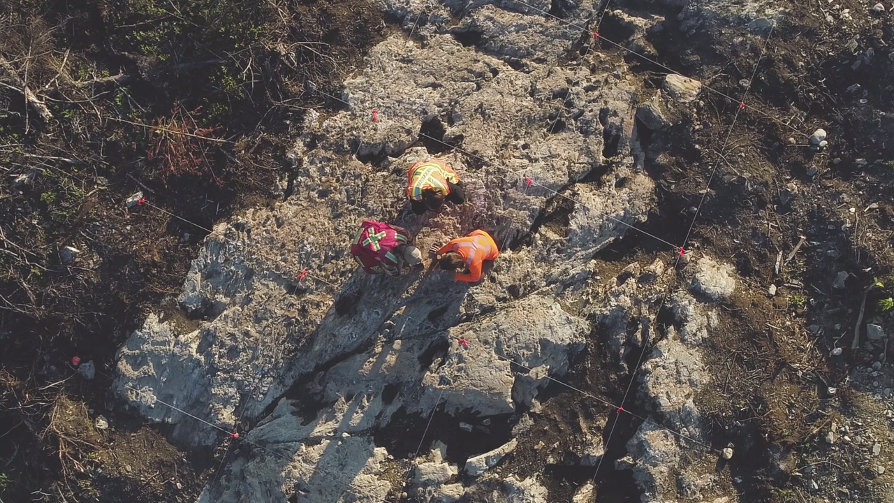
Image Caption: Image of Danielle Shirriff, Brendon Samson, and Naomi Welt looking at microstructures while mapping an outcrop in detail. Grid lines were set up to allow researchers to measure and plot contacts, structures, veining and other details with accuracy, to show specific geological relationships not otherwise shown on a larger scale map.
Scope of Project:
The Metal Earth Malartic transect mapping and research project was initiated by the Mineral Exploration Research Centre at Laurentian University in 2017. It was designed to be multidisciplinary in scope and thus involved various scale targeted bedrock mapping, in conjunction with detailed structural analysis, lithogeochemistry, U-Pb geochronology and mineral deposit investigations. In addition to these fundamental geological techniques, extensive gravity, aeromagnetic, magnetotelluric and seismic data were newly acquired along the transect and are being processed by our geophysical colleagues.
The intent of this multidisciplinary project is to refine the crust architecture and to elucidate the critical geological processes that led to metal endowment, in comparison to less metal-endowed Archean terranes. Field work was done in 2017 and 2018, with a short follow-up season planned for this summer. The study area extends from Berry township in the north to Mourier Lake in the south, and is bounded by Highway QC-395 to the west and Highway QC-397 to the east. This area (roughly 50×100 km2) comprises Neoarchean volcanic terranes and sedimentary basins that are intruded by batholiths of various composition. Multiple crustal scale structures (e.g. Larder Lake-Cadillac break) and regional faults (e.g. Manneville faults) are spatially associated with numerous gold mines and less-known nickel occurrences.
Major scientific topics include:
1) Contact relationships between the Cadillac basin and Piché structural complex, which defines the Malartic segment of the Larder Lake-Cadillac break;
2) Structural evolution of crustal scale deformation zones and its implications for differential metal endowment;
3) Structural evolution of the Cadillac basin and its implications for gold mineralization;
4) Ore genesis and structural modification of nickel mineralization within the Southern Manneville deformation zone;
5) The emplacement of the S-type La Motte batholith and its constraints on timing of regional deformation;
6) Provenance and evolution of sedimentary basins in southern Abitibi and Pontiac subprovinces.
Anticipated Outcomes:
All field and analytical data will be organized and stored in the Metal Earth geodatabase. A cross section across Abitibi and Pontiac subprovinces with integrated geological and geophysical interpretation will be completed. Research on different topics will be published in format of technical reports, M.Sc. theses and peer-reviewed journal papers. Highlights of our work will be presented in various domestic conferences and workshops. Collaborations with university, government and industry partners may stimulate novel ideas for future projects.
Malartic Map:
Transect Research Projects
Project Title: |
Researcher: |
|
Brendon Samson, MSc, Laurentian University
|
|
|
Mobilization of Ni-Cu-(PGE) mineralization at the Cubric showing along the Southern Manneville fault zone, southern Abitibi Subprovince, Quebec |
Danielle Shirriff, MSc, Laurentian University |
Related Documents/News:
Ontario Geological Survey Summary of Field Work 2018
Metal Earth GeoHub - Malartic Related Documents

